Leica Geosystems and MicroSurvey Software launched IMS Map360, the core product in the new Leica Geosystems Incident Mapping Suite of software. IMS Map360 employs an exclusive...
Leica Geosystems released the Leica ScanStation PS15, the latest innovation for public safety professionals.The Leica ScanStation PS15 combines the time-tested performance of ...
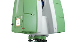
Leica Geosystems has announced the launch of its latest versatile 3D laser scanner, the Leica ScanStation P15. Combining high performance scanning with a user-friendly interface...
Leica Geosystems' Zeno CS25 GNSS is a tablet computer which packs full GNSS functionality into an ergonomic and portable device with a large screen, making it a powerful GNSS/...
Leica Geosystems introduced a new tool that definitively validates the accuracy of forensic 3-D laser scans made using the Leica Geosystems ScanStation C10. The ScanStation C10...
Old buildings? No documentation? Irregular walls? Details to locate? Inaccessible points to measure? No need to worry: the Leica 3D Disto measures it all. Simply aim the 3D Disto...
Leica ScanStation C5 is a fully integrated, cable-less system. The scanner has an easy-to-learn onboard interface with high-resolution, color touch screen and integrated, high...
Leica Geosystems announces the HDS7000, a new phase-based laser scanner that lets users take advantage of ultra-high speed scanning for more scanning applications on more sites...
By Leica Geosystems makes available a seven-hour “live fire” shooting reconstruction workshop titled “3D Laser Scanning of Shooting Scenes and Trajectories” taught by Mike Haag...
The Leica Viva TS15 adds a high-resolution camera to further enhance total station productivity. Traditional robotic operation is significantly improved with imaging features ...
Leica Geosystems, industry leader in measurement technology and a Badge of Honor Annual Partner of the National Law Enforcement Officers Memorial Fund, has formally renewed its...
Commitment honors law enforcement heroes while enabling Leica Geosystems customers to give back to the law enforcement community with every Leica Geosystems purchase.
Oct. 17, 2014
Articles
Agent Clint Norris, New Mexico State Police Crime Scene Team
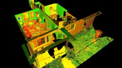
A new way to capture crime scenesHow 3D scanners, laser scanners and advanced cameras are revolutionizing investigation as we know itProcessing a crime scene--taking pictures,...
The judges of the Cygnus Law Enforcement Group 2007 Innovation Awards had a tough job deciding who would receive the trophies. Here is a complete list of the finalists in each...
The entries were judged on their innovativeness, productivity, quality, contribution, ease of use and maintainability by a panel of six distinguished law enforcement professionals...
Leica Geosystems new eLearning modules are available online 24/7 from any location with a PC and an Internet connection. Students can progress through the material at their own...
A powerful new registration option lets users automatically register scans together via inexpensive black-and-white paper targets, without the need to label scan targets. This...
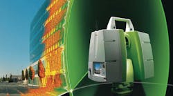
The compact, all-in-one ScanStation C10 platform from Leica Geosystems includes a scanner, tilt sensor, battery, controller, data storage, auto-adjusting video camera and laser...
With the introduction of the new Leica Zeno GIS series, it has never been so easy to manage and maintain assets, inspect infrastructure, respond to emergencies, ensure public ...
Leica Geosystems' relationship with Digital Aerial Solutions (DAS) was further strengthened by DAS' purchase of Leica Geosystems' ALS60 airborne LiDAR scanner, the company's third...
The Leica TM30 succeeds the highly acclaimed Leica TCA2003 and TCA1800 total stations and is designed specifically for monitoring applications. It incorporates accuracy, reliability...
A four-constellation Global Navigation Satellite Systems will soon become reality, delivering a new dimension in GNSS performance and efficiency. Leica Geosystem's future-proof...
Leica Geosystems announces the introduction of a new medium format digital aerial camera system designed specifically for use with its ALS-series airborne LIDAR systems. The new...
The Leica ALS60 Airborne Laser Scanner builds on the legacy of productivity, accuracy and flexibility that have made Leica Geosystems' ALS series instruments the fastest selling...
The Leica XPro line sensor workflow is straightforward to implement and easy to use for those familiar with the traditional analog frame processing. Ground processing with Leica...
The features and functionality incorporated into the Leica SpiderWeb version 2.2 GNSS Internet reference station data distribution software by Leica Geosystems delivers data usability...
The ScanStation 3D laser scanning system from Leica Geosystems allows investigators to digitize and map a scene exactly how the first responder encountered it. The ScanStation...