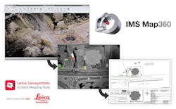
Leica Geosystems and MicroSurvey Software launched IMS Map360, the core product in the new Leica Geosystems Incident Mapping Suite of software. IMS Map360 employs an exclusive template system and easy-to-use tools to provide a simple data-in, diagram-out workflow that can be used with a variety of evidence collection methods and sensors to dramatically simplify scene diagramming.
The scalable software enables users to create basic scene diagrams with easy and intuitive tools, quickly generate evidence logs of points, and develop compelling exhibits from measurements. Optional extensions allow users to quickly and easily incorporate point cloud data, create powerful and accurate animations, and combine 2D and 3D data from multiple sensors for consistent and repeatable results. Users can enhance their exhibits by adding geospatial and contextual awareness with rich, high accuracy, 30-cm resolution imagery from the exclusive Hexagon Imagery Program (HxIP).
Through a customizable Experience Mode, users can tailor the software interface to meet their needs and experience level, from easily creating millimeter-accurate 2D layouts of incident scenes and surroundings, to accessing engineering-grade professional tools to create the most sophisticated 3D CAD diagrams and animations.
IMS Map360 is fully compatible with Leica Cyclone software and utilizes Leica JetStream, a new high-performance, streaming data server that super-charges the user experience when working with large data sets. “Public safety professionals have long wanted a way to simplify the day-in, day-out task of creating accurate scene diagrams from measurements. IMS Map360 directly addresses this need,” said Chuck Coiner, manager of the Leica Geosystems Public Safety Group. “This is the first software in the industry that supports multiple geospatial measurement sensors while providing the option to simplify the user experience based upon experience level.” “The intuitive interface, easy-to-use tool sets and incredibly precise, engineering-grade, industry-leading 3D CAD engine in IMS Map360 makes it simple for users to create almost any type of exhibit—from simple 2D sketches and 3D drawings to models and full animations,” said Jason Poitras, general manager of MicroSurvey Software Inc. “IMS Map360 ushers in a new era of simple data processing by allowing public safety professionals to focus on quickly completing their required diagramming.”