ALS60 Airborne Laser Scanner
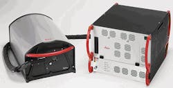
The Leica ALS60 Airborne Laser Scanner builds on the legacy of productivity, accuracy and flexibility that have made Leica Geosystems' ALS series instruments the fastest selling airborne LIDAR systems in the industry. Leica Geosystems' third-generation LIDAR system, the Leica ALS60, continues to break traditional paradigms such as having to choose between rapidly-acquired, high-density data and achieving outstanding accuracy - or having to choose between a compact system and one with high-altitude performance. The Leica ALS60 allows accurate data collection independent of pulse rate, depending instead only on flying height. In addition, it‘s flying height envelope ranges from a helicopter-compatible 200 m AGL to 5000 m AGL for wide-area mapping.