Esri GIS—Providing the Geographic Advantage for Intelligence-Led Policing
Law enforcement and criminal justice personnel use GIS technology by Esri to effectively perform emergency response planning, determine mitigation priorities, analyze historical events, and predict future events. GIS is used to get critical information to emergency responders upon dispatch or while en route to an incident to assist in tactical planning and response. The breadth and scope of GIS in Law Enforcement is endless. GIS is used by local, state, and federal law enforcement agencies for crime and investigative analysis; community policing and public information dissemination; criminal justice and intelligence; corrections, parole, and probation; management analysis and geoaccounting; resource tracking and management; mobile/in-vehicle mapping; emergency/event management; 911 communications, and Megan's Law.
Esri's ArcGIS software provides law enforcement agencies with the ability to visualize, analyze, and even forecast problems as well as manage data to provide a more effective and proactive response. Whether you work as a police chief, commander, investigator, or patrol officer, ArcGIS enables you to leverage a full suite of tools for intelligence-led policing.
GeoComm announces the availability of three GIS Services Package Offerings for on-going GIS data remediation, normalization, and maintenance. These packages provide local governments...
ArcGIS Server is a complete and integrated server-based geographic information system (GIS). It comes with out-of-the-box, end user applications and services for spatial data ...
ArcGIS, organizations can fuse complex, disparate datasets, including GeoRSS feeds, live traffic camera feeds, and live weather feeds with their existing data to ensure complete...
ROME, New York, 5 February 2020 – PAR Government, a provider of geospatial and decision support services and tools to the U.S. government for 50 years, will showcase its newest...
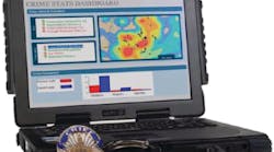
When the Oklahoma Highway Patrol wanted a solution to enhance officer safety and increase efficiency, the agency looked no further than Esri® technology.
Esri announced the availability of the ArcGIS Open Data Initiative for Law Enforcement, which allows police agencies of any size to build and share authoritative data for better...