Oklahoma State Police Save 889 Miles and 14 Hours of Travel Time
When the Oklahoma Highway Patrol wanted a solution to enhance officer safety and increase efficiency, the agency looked no further than Esri® technology.
The Challenge
The Oklahoma Highway Patrol (OHP) leadership wanted to modernize its operations. It wanted a solution that could provide a critical, real-time view of where its on-duty troopers are as they patrol Oklahoma’s highways. OHP has 800 troopers; 13 communication centers; and more than 111,000 miles of roads, highways, and waterways. The management of so many personnel over such a wide geographic area was daunting, and automatic vehicle location (AVL) solutions were cost prohibitive.
The Solution
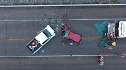
OHP conducted a 90-day test to find out how many miles and hours in travel time would be saved by making dispatch decisions using Workforce for ArcGIS. In responding to 28 collisions and 23 cases where motorists needed assistance, the test showed a savings of 889 miles and 14 hours in travel time, according to OHP captain Ronnie Hampton. “Mileage is a savings of fuel. Hours [saved mean] a quicker response for the public. The greatest benefit for Oklahomans is the faster response times, especially in rural areas,” Hampton said. “The people that benefit from this are the public, by being able to have someone at the scene in 3 or 4 minutes versus. . . 45 or 50 minutes,” he said. “That’s where your hours of savings come in.”
The Results
Most of the information and capabilities in the Dispatch Map are available to on-duty officers using the Trooper Field Map in ArcGIS Online, accessible via the in-car computers mounted in their vehicles. The troopers now have access to shared maps that give them increased situational awareness and help them communicate information about traffic conditions, accidents, and pursuits in real time.
OHP has now expanded its use of ArcGIS to include Esri Story Maps apps for briefings and to share information with the public and assist in prosecutions. In the near future, OHP plans to use Drone2Map® for ArcGIS to aid in accident and crime scene investigations.