The H520 with RTK (Real Time Kinematic) System Option
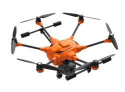
The commercial hexacopter, the H520, will now optionally be available with an RTK (Real Time Kinematic) system from the Swiss company Fixposition. Even under difficult GPS conditions, such as in cities or canyons, the RTK system ensures maximum precision and centimeter-precise positioning. The fully integrated RTK satellite navigation enables extremely accurate recurring images, faster 3D mapping and makes automated inspection flights easier and more precise.
The RTK system is not only fully integrated into the hardware, but also into the UAV's software. This means the user retains the full range of functions of the award-winning DataPilot™ software at their disposal, including mission flights. The H520 RTK works with two components: the RTK module on board the H520 and a base station on the ground. For precise navigation, the module supports constellations of up to three different satellite systems from GPS, GLONASS, Galileo and BeiDou.
If the use of a ground station is not possible, the system can also be operated with a national reference station network (network RTK). The network RTK is provided by third-party providers and requires an Internet connection, such as a mobile hotspot. All data including satellite data is recorded, which makes the H520 RTK ideal for Post Processed Kinematics (PPK).
The H520 RTK will be available in the second quarter of 2019 in different configurations: as a complete system including the H520 airframe and RTK module, for $3199, and as an upgrade for existing H520 customers for $1699. The H520 RTK GPS ground station will be sold separately for $2399.
The complete technical data of the Yuneec H520 with RTK system can be found at us.yuneec.com/h520-rtk.