Since the Spotsylvania County Sheriff’s Office in Virginia stood up its drone program about three years ago, it has been able to deploy unmanned ariel vehicles for a myriad of uses
“We support patrol when they have incidents such as runaways or missing people. If they have car accidents sometimes, we’ll support them on traffic problems,” says Deputy Mike Christie. “One of the most important things is that as soon as we have somebody missing, we can get on scene pretty quick. We have a vehicle with all of our equipment, and we have a driver that is nearby the office who can jump in it with myself and anybody else.”
This article appeared in the September issue of OFFICER Magazine. Click Here to view the digital edition. Click Here to subscribe to OFFICER Magazine.
Spotsylvania County has a heavy population area, but also has quite a bit of rural area. Also within the county is Lake Anna, which is one of the largest freshwater inland reservoirs in the state. Covering an area of 13,000 acres, it was created in 1972 to support the North Anna Power Station. Responses to the lake usually involve calls for drowning victims, missing persons or boat crashes.

“We have our search team that will get out and we can support the ground units in a couple of different ways by doing overwatch for them, we can drop water bottles if they need water, or first aid packs if there is no medic there,” says Christie. “We have several different attachments that we can attach to the drones to look for missing people.”
Earlier this year, the Spotsylvania County Sheriff’s Office responded to a reported drowning on its side of the lake. The drone team provided quick coverage of the area and located a flipped vessel in about 20 minutes. Divers were able to enter the water and quickly recover the body.
“We put people out along the shore thinking that possibly the subject had gotten to shore,” he says. “We were able to search that shoreline pretty quickly once we found the boat to make sure the subject hadn’t gotten to shore.” He says that without the use of drones, the search would have been very difficult to execute. “It takes time to get boats out into the water, get them launched and get them into that particular area. Timewise, we got there pretty quickly.”
Part of a three-county area, Spotsylvania County once considered purchasing a helicopter for search operations with its neighbors. The cost was still astronomical, and none of the jurisdictions agreed to the purchase. “For us, this was a win-win situation,” says Christie, who was able to secure a grant to start up the drone program. “Each jurisdiction now has its own drone and we can support each other that way. If something happens in Jurisdiction A, we can go over there and help them and vice-versa.”
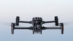
The sheriff’s office drone fleet includes a DJI Matrice 210, two DJI Minis and a DJI Mavic. “For me, because I came into it brand new, you have to do your homework. Do some research. There are grants out there for people to explore,” he says. “Agencies need to make sure they do training. You’ve got to get out there and work with other units within your agency and train with them, such as K-9 and SWAT.”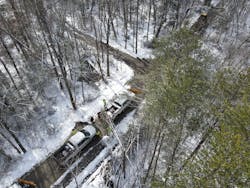
Michael Rogers, Vice President of Public Safety at SkyFire who spent 22 years as an FBI Special Agent where he managed and grew the Bureau’s UAS program, spoke to OFFICER Magazine about how the company has helped agencies get their drone programs off the ground. “Where Skyfire has really excelled is finding people who have particular expertise in public safety,” he says. “We’re advising on best equipment, software and hardware. We’re doing a lot of the training and we’re consulting on pricing with retailers that have the best products and pricing.”
He says that agencies must figure out what the mission is when drones are considered. “We’re trying to get away from ‘We bought a drone as an agency, now what do we do with it?’ We want to go specifically toward here are the two to three needs an agency has where drones are the most benefit to them for the cost in order to build a program.”
Rogers lives near Spotsylvania County and is familiar with Lake Anna, where the drowning response occurred. “I’ve been on that lake quite a bit. It’s a big lake. It’s hard to prepare for how dark it is over a large lake in the middle of the night. In this circumstance, it was middle of the night. This is a reservoir, but there are multiple bodies of water in the area here. At night it’s particularly hard to get light out there without putting boats out there or crewed aircraft.”
Being able to put a spotlight or thermal imaging camera above the lake with a drone, is a big step, he says. “I think trying to find that boat on shore walking around with spotlights and waiting for boats and waiting for other assets to get there; the drone was able to pop up really quick, and be able to see with the thermal and find that object, which was flipped over and flat surfaced on the water. So, it’s not visible easily on shore quickly.” From there the agency was able to send divers to that spot, work on the currents and search that area as opposed to the entire lake.
“There’s a lot of issues out there. You think the population centers are where all of the problems are, but problems are everywhere,” says Rogers. Not only do trees, forests and heavy grass pose an issue, but places like Iowa in August have 10-foot cornstalks in fields that stretch for miles.
“When you are trying to search for a small person in that kind of environment, it’s a massive undertaking on foot,” he says. “In the past, typically there wasn’t heavy crewed aircraft availability for a lot of these departments in rural areas. It seems like a lot of the crewed aviation programs that I’ve worked with in the past are big city programs. There aren’t programs in Iowa and those places. You are talking about vast areas that are very difficult to search. A UAS gives you a tremendous bird’s eye view.”
Rogers says there’s been big strides made in the technology included on drones and that eventually it will go from a drone with a camera trying to find heat or capture an image to being equipped with an advanced array of sensors and an advanced array of AI to follow on the software side. This would allow the drones to measure and detect cellular or Bluetooth signal in a rural area.
“Traditionally you would search lower areas because that is where they ran to, but now they want to go to high areas because they want to get a signal,” says Rogers. “We can put these drones up in high terrain, difficult to reach areas, and find these people by getting a signal based on the electronics on their body.”
James Bushey, Director of Technical Services for Adorama Drones, says remote locations come with their own set of challenges. The first issue is connectivity. “While the drone and controller do not need an internet connection, oftentimes the live feed from the drone is transmitted back to a command center or other location for officers to watch. Having no cell service limits the ability for the drone to transmit the feed, which can lead to the operators being the only ones with visibility into what the drone sees.”
Bushey adds that another challenge when operating drones in remote locations is power. “Even the most robust enterprise systems are limited in flight time, with 40 to 50 minutes being the maximum,” he says. “Remote locations do not have power to charge batteries, meaning the pilot must make sure to charge the batteries before leaving. Another option is an external power supply, which can be used to charge batteries remotely.”
This article appeared in the September issue of OFFICER Magazine.
About the Author

Paul Peluso
Editor
Paul Peluso is the Managing Editor of OFFICER Magazine and has been with the Officer Media Group since 2006. He began as an Associate Editor, writing and editing content for Officer.com. Previously, Paul worked as a reporter for several newspapers in the suburbs of Baltimore, MD.