Technology Improvements Aid in Search and Rescue Operations

The type of search and rescue (SAR) incidents law enforcement encounter vary from state to state and agency to agency. No matter the region of the SAR mission, technology to assist in SAR incidents has drastically improved in the last decade, increasing officer safety and creating efficiencies along the way.
Communication improvements and new apps
Communications is one technology that has seen improvements. When Hurricane Ike barreled into the Texas coast in 2008, it wiped out not just physical structures, but decimated the cellular infrastructure as well, hindering search and rescue operations for the Texas Search & Rescue team (TEXSAR) says Brandon Goering, planning section chief of TEXSAR. “There were no cell phones to be had and communications were extremely limited,” he recalls of the natural disaster.
Nine years later when the team deployed to Hurricane Harvey, Goering recounts a different story. “As far as the infrastructure goes for mobile communications throughout the entire operation, they were up with the small exception of a few places,” he says. “I was impressed with that. Not only were we able to make calls most of the time, but we could share data.”
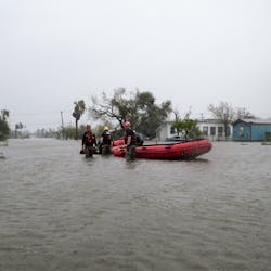
Communication during SAR efforts is critical for not just the safety of the civilians, but for the safety of first responders as well. Fortunately, technology advancements, including law enforcement radios that are LTE-capable, have helped first responder communications become more reliable in the last few years.
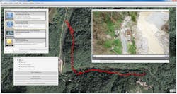
There was also a greater situational awareness for the TEXSAR teams during this SAR operation, thanks to new applications that allowed them to track each other. TEXSAR uses a combination of its traditional VHF radios as well as apps to communicate and keep tabs on each team’s location. The organization uses a software suite from Terrain Navigator Pro, a mapping platform combining built-in topographic maps and aerial photos. “In Terrain Navigator Pro, whenever you’re signed in, we can see on the map where people are on the field,” says Goering. The software allows TEXSAR to create map projects, annotate, edit, collect, import and export GIS data and maps, among other things.
New products and improvements to an old one
Another technology that is quickly coming onto the SAR scene are unmanned aircraft systems (UAS), commonly referred to as drones. The perspective that drones give to law enforcement and SAR teams makes the newer technology beneficial, and across the U.S., law enforcement agencies are purchasing drones to aid in search and rescue operations. Late last year, utilizing a small unmanned aircraft system (sUAS), the Loudoun County Sheriff’s Office (Va.) safely located a 92-year-old hunter lost in a heavily wooded area of Shenandoah County. The drone reportedly visually located the subject in just 20 minutes. In a press statement, Loudoun County Sheriff Mike Chapman said, “This new technology allows our deputies to more efficiently search for missing persons…and bring them home safe.”
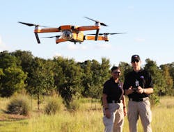
TEXSAR’s Goering calls drones a “game-changer” in SAR missions. “I think we are only limited by our imagination right now,” he says. “We are still scratching the surface.” Though his team specifically did not utilize a drone during Hurricane Harvey relief efforts, he says it would have been useful to have in several places, to see exactly what they were getting into. “We were working in Galveston County and responding to 911 calls,” he says. “Getting from point A to point B in some flooded areas was very problematic. If we could have had an aerial view to learn if an area was passable, that would have completely helped.”
In addition to utilizing a drone to find the missing hunter last year, the Loudoun County Sheriff’s Office used thermal imagers, another technology that has improved and helped in SAR missions.
Over the last decade the price on thermal imaging instruments has gone down even as the performance has increased, making it easier to obtain for budget-constrained departments. Ten years ago, the Sergeant Bluff Police Department (Iowa) would not have been able to afford thermal imaging technology. With end-of-year funds, however, the agency was able to purchase a FLIR Scout TK and improve officer safety on a SWAT-turned-SAR incident last year.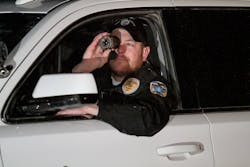
“We had an officer-involved shooting where one guy ended up running off at night in 0 degree temperatures,” says Chief Scott Pack of the Sergeant Bluff PD. Pack grabbed the department’s FLIR and scanned a 2-mile perimeter where officers were stationed, looking out among cornfields and bean fields to make sure there were no thermal signatures. “This allowed the officers who were holding the perimeter to relax knowing there wasn’t anyone in the field sneaking up on them at night,” he says. Though the incident initially began as a SWAT-response mission, the freezing temperatures quickly changed the incident into search and rescue of the suspect. “I think the biggest thing FLIR technology did during that SAR mission was to take the unknown to the known level,” says Pack, “which allowed us to operate and to do our job more effectively.”
Pack says it wasn’t a hard decision to make to purchase the FLIR Scout TK, due to the price decrease over the years. At last the technology got to a point his department of eight sworn and eight reserve officers could afford. The price wasn’t the only selling point. Compared to other federal government thermal equipment Pack had, the FLIR was much lighter and easier to deploy. “We took the equipment from the bag to the field in less than five seconds,” he notes.
Dave Dennis, director of sales and marketing for FLIR agrees that technology has greatly improved in performance and price, to the benefit of law enforcement. “In the mid 2000s you could get a thermal weapon sight that was the size of a toaster that would be low resolution, ate batteries like crazy, weighed a lot and cost about $50,000,” he says. “Now in the last 10 years technology is down to something that can fit into the palm of your hand with higher resolution, better performance, runs off of disposable and rechargeable batteries and costs a few grand.” And it’s something smaller- and medium-sized departments can utilize to create efficiencies in SAR missions and to keep officers safe.
As technology changes
It can be shocking to see how quickly technology has changed in the last decade, but TEXSAR’s Goering notes there’s still more growth needed in some aspects. “Quite often kids these days are carrying a smartphone that can do more than what a trained rescuer is able to do with their technology and there seems to be quite a gap,” he says. “We are closing that gap, but there’s still more improvement to be done.”
In the coming years improvements will continue to be made on current technologies being deployed in SAR operations and new innovations will emerge, each aimed at improving efficiencies and increasing safety for LEOs and the subjects they rescue
About the Author

Adrienne Zimmer
Editor
Adrienne Zimmer was the Editor of Law Enforcement Technology magazine, a monthly business-to-business publication that covers technology trends and best practices for public safety managers from 2017 to 2019. LET is part of Officer Media Group, which also publishes Law Enforcement Product News and Officer.com. Adrienne has been in publishing since 2013.