How Shrinking Technology can Advance Search and Rescue
Search and Rescue or also known as Search and Recovery (both referred to hereinafter as “S&R”) are both about two things: access and visibility. At their most basic, access and visibility simply require us to be able to get ourselves into the right position to see what we’re looking for—that it is where we’re looking or that it’s not. In the old days, before the development of any type of electronic technology, our ability to perform any type of S&R activity was limited by our own mobility and eyesight. We used to be limited by something as simple as the difference between night and day. Today that’s far less of an issue.
With the development of some simple technologies like the flashlight we doubled (or more, depending on the season) our time available to perform searches. We also extended the distance we could see giving us access to areas we previously would have been denied simply due to light availability. While the simply flashlight has evolved to produce more light in a focused fashion, it’s done so in smaller packages with longer lasting power supplies.
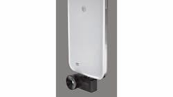
What other devices have assisted us in our S&R capabilities? We realized that even with a sufficient amount of light there are places we can’t see due to items that block our line of sight, or that there are still places we can’t get enough light into. In those situations, we’ve developed technology that lets us see in different frequencies; technologies like infrared and/or thermal technology. Those technologies used to be rather large and heavy, making them only practical for vehicle deployment. Nowadays, you can get a small device like the SEEK Thermal or other similar attachments for your cellphone to turn it into a thermal vision device. The cellphone itself already serves as both a still camera and a video camera and can be used near simultaneously to compare captured images to databased images for verification of value or to be discarded.
Thanks to the mobility and convenience of use for cellular phones and tablets/iPads, apps have been explosive. There are apps to do almost anything including such S&R related items as mapping, navigation, multi-frequency scanning (radio), multi-frequency searching, tracking search paths and so much more. Gone are the days of having a 10-pound infrared camera mounted to the underbelly of a helicopter or the top of a cruiser’s light bar.
Now that power is right in your hand—or close to it.
Speaking of helicopters, it’s no secret that being up higher to look for anything increases our field of view and thereby our chance to see what we’re looking for. The use of drones (or unmanned remote controlled aerial vehicles) greatly enhances the ease of application for using height to our advantage. And thanks to the miniaturization of all of the related technology, even a small drone can be outfitted with an adjustable camera to allow us to see in multiple light wavelengths. Some video capture and edit applications now incorporate geo-tagging, so a drone operator searching for a lost hiker can find the hiker by identifying his body heat and then tag his location using the GPS and navigation overlays built into the videography application. Once that location is transmitted to ground responders, it’s only a matter of time before rescuers can get to the hiker to rescue him.
None of these capabilities existed as little as 20 years ago. The size and weight of the related technologies was too great to make them feasible. However, as technology continues to be miniaturized and ruggedized, greater application of the tech is made available. How long will it be before a state or county puts together a coordinated rescue team comprised of people, drones, remote controlled ground vehicles and all of the related visual spectrum technology?
Pretty soon, sometime in the next ten years or less would be my projection, such a team will exist. The team leader will simply have to turn on his tablet, take control of all of the drone/remote vehicles assigned to the team and get them going. All of them will be controllable from a single device and the data from all of them will be consolidated into and interpreted by that same device. With the touch of a button or swipe on the screen, the team leader will be able to change visual spectrum being searched and feed that imagery—filtered through a software application that maximizes the value of data received and likely combines it into a more useful 3D image to include topography, etc.—and see more than the naked human eye ever could. By use of such technology, searches will be far more efficient, equally less risky and SHOULD result in faster rescues for those lost.
About the Author

Lt. Frank Borelli (ret), Editorial Director
Editorial Director
Lt. Frank Borelli is the Editorial Director for the Officer Media Group. Frank brings 25+ years of writing and editing experience in addition to 40 years of law enforcement operations, administration and training experience to the team.
Frank has had numerous books published which are available on Amazon.com and other major retail outlets.
If you have any comments or questions, you can contact him via email at [email protected].