Ground-Based Surveillance Systems (GBSS) for BVLOS DFR Operations
By David Cameron, Field Services Engineer, MatrixSpace
A limitation in UAS operations for DFRs (Drone as First Responder) programs is the requirement for visual line-of-sight (VLOS) of the Remote Pilot in Command (RPIC). It limits DFR operations, particularly in urban areas where buildings obstruct the pilot's line of sight. The Federal Aviation Administration (FAA) offers waivers to DFR operators to fly UASs beyond visual line of sight (BVLOS), current DFR BVLOS operations require the RPIC and or VO to maintain observation of a 2-mile operational volume around the area of the drone operation and not necessarily the drone itself to maintain situational awareness and ensure safety during the operation.
To remove these burdens and make DFR operations more scalable, alternative methods of collision avoidance are therefore being considered and are starting to be adopted. One is radar technology for Ground-based Surveillance Systems (GBSS).
Solving BVLOS with GBSS
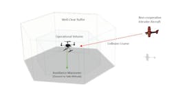
GBSS prevent interference or collisions between UAS and non-cooperative crewed aircraft within the same airspace - UASs must maneuver and maintain well-clear distances when potential conflicts with other aircraft are detected. The GBSS actively surveils the surrounding airspace, scanning for non-cooperative aircraft that may pose a threat to the safety of person and property during a DFR operation.
This allows DFRs to operate UASs safely BVLOS, enabling either the RPIC to take avoidance actions or the UASs to autonomously perform collision avoidance maneuvers and adjust their flight path.
Currently there are three RPIC actions recognized by the FAA:
Automated Maneuver
The UAS reacts autonomously to avoid non-cooperative aircraft. The time penalty recognized by the ASTM DAA performance standard and adopted by the FAA is one second.
Directive Maneuver
The RPIC is alerted of an intruder aircraft and initiates a pre-programmed avoidance maneuver. The time penalty recognized by the ASTM DAA performance standard and adopted by the FAA is five seconds.
Suggestive Descent
It is left to the RPIC to assess the threat and decide the avoidance maneuver and its execution. The time penalty recognized by the ASTM DAA performance standard and adopted by the FAA is 15 seconds.
But first, some terms for clarification:
|
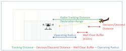
Surveillance Range/ Volume |
Distance between radar detection and track established |
|
Declaration Range/ Volume |
Point at which a track has been established, location and velocity vector are available |
|
Well-Clear Distance |
Distance to meet ASTM clearance requirements (2000ft/610m horizontal and 100ft vertical), minimum separation distance |
|
Operating Range/ Volume |
Area at which the DFR operation can be conducted allowing sufficient time to initiate and execute avoidance maneuver and have a WC buffer distance between UAS and intruder. |
|
Safe zone/altitude |
A portion of airspace in which UAS is considered Well-Clear from intruder crewed aircraft, regardless of horizontal or vertical distance between UAS and intruder. |

To strike a balance between allowing RPICs sufficient reaction time for avoidance maneuvers and maintaining a safe distance from non-cooperative crewed aircraft, Appendix A of the RTCA DO-381 [1] standard has been used for the worst-case scenario calculations. It grants RPICs adequate reaction time to execute avoidance maneuvers while ensuring a well-clear distance from non-cooperative crewed aircraft. By adhering to the Appendix A calculations, DFRs can assess the real-time operating airspace for each UAS flight, considering factors such as the UAS's speed, descent rate, the speed of non-cooperative aircraft, and reaction times of the RPIC. Through this standardized approach, DFRs can ascertain a safe detection volume for the radar-based GBSS, allowing it to scan and detect non-cooperative aircraft effectively.
The further the radar system can scan, the larger the DFR operating volume becomes, allowing more time for critical avoidance maneuvers. Thus, achieving an optimal range extension while still maintaining commercially viable GBSS is of high importance in the DFR community.
Optimizing DFR Operational Volume
The main concern of DFR customers and integrators is: “What is the radius/area of my DFR Operational Volume?” How large is my Operational Volume? How much time does the UAS have to get to a safe altitude after an intruder aircraft has been detected (the radar started tracking).
Optimizing the Operational Volume (OV) for DFR operations is essential for successful adoption and deployment.
To estimate that time (which translates into distances), we can use the following example:
What distance has the intruder aircraft traveled by the time the UAS has descended to a safe altitude?
Add to that distance the airspace safety clearance requirement of 2000ft/610m.
Now add #1 and #2 and subtract from the distance the intruder aircraft was when the radar started a track.
Consider the worst-case scenario at which the intruder aircraft is the shortest time/distance from a collision with a UAS at the outer edge of the operating volume. The operating radius is calculated as follows.
- Decision & Descent Distance traveled.
- Intruder distance traveled before decision.
- Intruder velocity [m/s] * time [s] to initiate the avoidance maneuver.
- Intruder distance traveled while executing the avoidance maneuver.
- UAS descent rate[m/s] * descent distance [m] to safe altitude
The intruder aircraft travels at 56m/s
The RPIC takes 5s to initiate the avoidance maneuver (Directive Descent – see above)
The system takes 0.1s to react to the RPIC input.
The UAS descends by 15m at a rate of 4m/s à 3.8s
That’s 8.9s in which the intruder aircraft has traveled 498m.
Add the Well-Clear Buffer
Now we add the regulatory Well-Clear Buffer of 610m which results in a 1108m separation needed between the point the intruder was first tracked and the outer boundary of the operating volume range.
The MatrixSpace Radar Tracking Distance is the main determining factor in driving the operating volume range.
Let’s assume a Radar Tracking Distance of 2000m, which in turn would result in an operating volume range of:
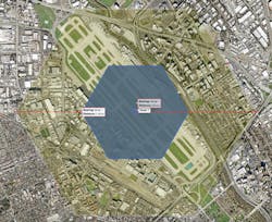
Below is an illustration of this scenario in a real-life situation with a single 360 Degree MatrixSpace Radar Node over San Jose (SJC) airport:
The blue area is the Operational Volume, the yellow area the Well-Clear Distance, plus the time traveled by the intruder from RPIC alert until the UAS has reached a safe altitude.
At a tracking range of 2000m the actual DFR Operational Area radius is 892m, resulting in an Operational Volume of 0.3 km^3 (@400ft/122m ceiling).
Empowering GBSS with extended range capabilities, it allows UAS operations to expand BVLOS – a game-changer for not just for DFR operations but a wide range of commercial deployments.
Learn more at:
https://matrixspace.com/matrixspace-radar/
https://matrixspace.com/public-safety/
https://matrixspace.com/advanced-intelligence-from-the-air-drone-as-a-first-responder/
About the Author
David Cameron, Field Services Engineer and Lead UAS Pilot with MatrixSpace, brings 33 years of service with the City of Campbell Police Department, where he held a variety of critical roles, most recently leading the department’s DFR (drone as first responder) operations. He remains a Reserve Officer. As Field Services Engineer and lead UAS Pilot at MatrixSpace he drives the UAS-oriented solutions for this advanced radar company, which is revolutionizing radar applications across diverse industries.
https://www.linkedin.com/in/david-cameron-33a30737/