Weather API Website for Public Safety
Baron' Weather API for Public Safety website is optimized for development. Baron Weather API for Public Safety makes it easy to integrate quality-controlled, industry-leading weather data into a range of devices and services, including location-based smartphone and tablet apps, websites, desktop applications, multi-function displays.
The Baron Weather API for Public Safety website offers customers an intuitive and customizable user experience, including a renovated documentation area with improved organization and faster access. With more customer dashboard features and convenient key display, customers can easily leverage Baron Weather API using any coding language, whether to track current conditions, view forecast conditions, or access historical data. Plus, new and improved use case ideas and descriptions for over 200 meteorological data products, including over 60 Baron exclusives, empower customers to develop creative solutions for their application.

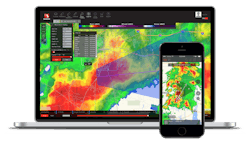
Timely and accurate storm tracking in Baron Weather API show the current locations of severe weather including hail, flooding rain, lightning, high winds, and tornadoes. The Baron Weather API for Public Safety also forecasts severe weather and gives an estimated time of arrival for the chosen community.
Other weather data products and features integrated by Baron’s Weather API include:
- Baron-exclusive Pinpoint Alerting, which sends alert notifications via text message, push notification and email when weather approaches specific locations of interest.
- Baron-patented Road Conditions data, which shows the localized impact weather has on surrounding roadways. Flooded, icy or snowy roads are pinpointed on the map, helping users determine the safest, most efficient routes up to 72 hours in advance.
- Exclusive Critical Weather Indicators, which highlight the location of potential tornadoes.
The cloud-powered Baron Weather API scales with customer demand to deliver secure and reliable data on time, every time. For efficient integration into any application or GIS platform, Baron Weather API features a streamlined on-boarding process and includes numerous data formats, including JSON and TMS. It also features RESTful architecture to ensure a familiar development environment. All data in the Baron Weather API for Public Safety is provided in a variety of different formats including ESRI and ArcGIS with the developer able to determine how to present the information. Additionally, data packages are fully customized, making integration easy and quick