Officer
  • Honoring The Fallen
  • Publications
  • Subscribe
  • Advertise
  • Forums
  • Contact Us
  • Vehicles & Fleet
  • Tactical
  • Training & Careers
  • On The Street
  • Investigations
  • Command/HQ
  • Technology
  • Virtual Academy
  • Stations
  • Podcasts
  • Product Guide
  • Topics
    Vehicles & FleetTacticalTraining & CareersOn The StreetInvestigationsCommand/HQTechnologyProduct Guide
    Resources
    ForumsProduct GuideHonoring The FallenBy ContributorsExpert InsightsPublicationsWhitepapersWebinarsOriginal ContentJobs
    User Tools
    SubscribeAdvertiseContact UsPrivacy PolicyTerms & Conditions
    https://www.facebook.com/officercom
    https://www.linkedin.com/company/officer-com
    https://twitter.com/officercom
    1. Command/HQ
    2. Technology
    3. Computers & Software
    4. Accident & Crime Scene Reconstruction

    MapScenes Forensic CAD 2013

    Oct. 10, 2013
    Related To: MICROSURVEY SOFTWARE INC. (MAPSCENES)
    Mapscenes Screenshot Web 11307323

    MapScenes Systems, the leading developer of accident scene mapping and reconstruction software, announces the 2013 release of MapScenes Forensic CAD – a full-featured desktop mapping tool used by forensic investigators and accident scene reconstructionists.

    • Forensic CAD, Capture, and PointCloud applications into a single product
    • New presentation tools like viewing georeferenced points in Google Maps and exporting georeferenced scenes to Google Earth
    • New productivity tools that simplify common tasks users perform every day, like converting their drawings between different units, or cloning vehicle symbols onto key points with different positions and orientations
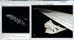
    • Support for the new Leica Nova MS50 MultiStation including full support for digitizing scenes directly within high-definition scans

    Request More Information

    By clicking above, I acknowledge and agree to Endeavor Business Media’s Terms of Service and to Endeavor Business Media's use of my contact information to communicate with me about offerings by Endeavor, its brands, affiliates and/or third-party partners, consistent with Endeavor's Privacy Policy. In addition, I understand that my personal information will be shared with any sponsor(s) of the resource, so they can contact me directly about their products or services. Please refer to the privacy policies of such sponsor(s) for more details on how your information will be used by them. You may unsubscribe at any time.

    Latest in Accident & Crime Scene Reconstruction

    Hilary Rodela
    Blog
    Accident & Crime Scene Reconstruction

    Eye for Evidence: Vehicle Accident Photos

    Hilary Rodela
    April 26, 2021
    Journal file/TNS
    Sheriff in Florida injured after being hit by car.
    Accident & Crime Scene Reconstruction

    Volusia Sheriff Mike Chitwood Injured After Being Hit by Car in Port Orange

    March 19, 2021
    Oscr360dallascounty
    Accident & Crime Scene Reconstruction

    Alabama Deputies Get New High Tech Crime Fighting Tool

    Feb. 17, 2021
    Baldwin County (Alabama) Sheriff's Office
    Initially, a fixed-wing pilot from Baldwin County received an additional 40 hours of training to fly the newly implemented drones. Additionally, several other officers went through 18 months of drone pilot training to earn FAA certifications.
    UAV / UAS

    Train, Fund, and Lift Off

    Paul Peluso
    Sept. 24, 2020
    Agent Clint Norris, New Mexico State Police Crime Scene Team
    3D imaging allows investigators to go back to the scene at any time.
    Forensics

    Bring Your Crime Scene to Life

    Agent Clint Norris, New Mexico State Police
    April 16, 2020
    Officer
    https://www.facebook.com/officercom
    https://www.linkedin.com/company/officer-com
    https://twitter.com/officercom
    • Contact Us
    • Advertise
    • Do Not Sell or Share
    • Privacy Policy
    • Terms & Conditions
    © 2023 Endeavor Business Media, LLC. All rights reserved.
    Endeavor Business Media Logo