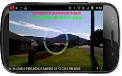
Red Hen Systems' MediaMapper Mobile (MMM) is a new Android-based app for handheld GPS integrated photo and video.
Compatible with Google Earth and Blue 2CAN devices, the app turns a mobile phone into a handheld GPS device and geotagging/audio recorder that does work faster and more efficiently than ever.
On-the-ground first respondents, construction managers, defense experts and even hiking enthusiasts can have top-of-the-line GPS multimedia technology with real-time data transfer capabilities in the palm of their hands.
The MMM app is a commercial-off-the-shelf (COTS) field device that geotags photos taken in the field using external or internal GPS for fast capture and storage to Android devices 2.3 and above. It track logs the data in NMEA and GPX formats.
The Android's positional information is associated with photos, features of interest (FOI) and voice annotations, which creates a comprehensive data collection device that assures accuracy during field missions.
Users can geotag media collected from "detached still cameras in the field using MediaGeotagger software. Business, management, and other professional users can coordinate up to six devices with MMM including True Pulse Laser Range Finders from LTI and Nikon cameras equipped with Blue2CAN Bluetooth devices to create a personal communication network. Shots can be automatically triggered for time or distance for use in helicopters during aerial field work or moving cameras on the ground.
After the pictures and video have been captured, users can send the data to a MediaMapper Server for easy storage and retrieval. All data can be instantly categorized and mapped with new Google Earth IsWhere mapping software for a smooth and familiar experience with little to no training. Government users can couple the app with more intricate FalconView and RouteScout software. The devices extract the GPS information and highlight the path of the selected mission for a seamless, interactive map that can be manipulated to carry out appropriate tasks for the industry.
The new components aim to make work easier for industries that value time and quality. MMM and its components is a more affordable package for emergency management, municipal work, defense and others to take advantage of mobile technology and popular mapping software that streamlines the process of capturing GPS capable data in real time.
