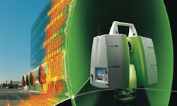
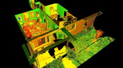
The compact, all-in-one ScanStation C10 platform from Leica Geosystems includes a scanner, tilt sensor, battery, controller, data storage, auto-adjusting video camera and laser plummet. ScanStation C10 also features major productivity advances, including a new Smart X-Mirror that lets users conduct full-dome scans in literally just minutes using a spinning mirror.
With performance for site, exterior, and interior applications, ScanStation C10 makes High-Definition Surveying (HDS) profitable for even more as-built, topographic and monitoring surveys. Users can take advantage of surveyor-friendly, onboard total station-like control or use an external laptop for even more powerful, onsite viewing and data processing.
Versatility
ScanStation C10 combines all-in-one portability with the ability of users to traverse, resection or use scan targets for maximum flexibility in dealing with site logistics. Full 360 degree by 270 degree field-of-view, high accuracy, long range (300 meter at 90 percent reflectivity), and high scan speed (50k pts/sec) add to ScanStation C10’s position as the industry’s most versatile scanner.
Major Productivity Advances
ScanStation is faster than its predecessor ScanSation 2 in many ways. It does full dome scans up to 10X faster – now, less than 2 minutes for a typical room. It also conducts general 360 degrees and focused areas scans faster, can be setup & moved faster, lets users locate targets, register and geo-reference faster, and lets users check scan results faster.
Valuable Cost Savings
ScanStation is easy to learn, with a total station-like interface and intuitive, onboard graphic color touch screen display. It is also incrementally upgradeable over time, uses standard total station batteries, and features fewer accessories.
All-in-One Construction
Familiar, total station-like interface
Leica ScanStation C10 supports standard field workflows with a rich, familiar total station interface.
Easy to learn touch screen operation.
Integrated real-time streaming video with zoom for fast, accurate selection of scene and targets to be scanned. The auto-adjusting, internal, high-resolution camera image can also be used for texture mapping of point clouds.
Smart X-Mirror design
The mirror automatically spins for fast 360 degrees and full dome scans and oscillates for efficient, targeted scans. The same Smart X-Mirror automatically aligns the internal camera image for fast, accurate texture mapping of point clouds.
Compatibility with standard surveying equipment
Attach handles with Leica GPS SmartAntenna or prism holder, or use without handle for unobstructed overhead scans. A built-in laser plummet and tribrach mount provide added compatibility with standard field procedures and accessories.


