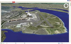
Airports, military bases, high profile government agencies and industrial complexes are among the first organizations to take a new approach to the highly complex world of security. AbeoTS’s Automated Warning and Response Engine (AWARE) takes an advanced, preemptive stance on security by automating all possible security scenarios and intelligently building rules into an engine for responding to event detection.
The sheer complexity of today’s security systems for large premises forces them to function as reactive (and often forensic) devices in the event of a security breach; with so many cameras and perspectives to monitor, security personnel are likely to miss events as they happen and spend hours manually searching for the events after they occur.
AWARE fulfills today’s security standards by providing instant detection, analysis and response in a single geospatial graphical interface, merging the dozens of separate data streams that usually result in sensory overload for monitoring personnel into a compelling GUI based on AbeoTS’s extensive 3-D expertise. The intelligent rules engine dramatically reduces false alarms, prioritizes and correlates events automatically, responds in real-time while facilitating multi-jurisdictional communication, and integrates into existing legacy systems and sensors.
In addition to prompt response to events, the AWARE solution increases manpower efficiency through its convenient sensor monitoring interface, reduced false alarms and instant, targeted event messaging. AWARE’s flexible architecture offers a truly scalable and repeatable security solution.
Also perfect for corporate campuses and other large complexes, the AWARE system has already been integrated internationally into four airports, two military bases and several industrial complexes.
Built-In Rules and Scenario Processor
AWARE’s event correlation engine monitors events from sensors, examines events for specific patterns and generates messages when specific patterns occur. The scenarios within the rules and scenario processor define the logic for detecting event patterns and message templates for broadcast to recipients.
A Geospatial Common Operational Picture (GeoCOP): The Control Center Simplified
AWARE’s geospatial control center integrates sensor data into an interface of satellite images and facility plans. The common operational picture empowers the security operator with lifelike images for intuitive navigation to isolate alerts.
Monitoring personnel can leverage the picture that GeoCOP creates to monitor vast areas, make security determinations quickly and accurately, and witness security activities as they unfold.


![Let 01 Cover0920 Digital Edition 5f4daeb1086a7[1] Let 01 Cover0920 Digital Edition 5f4daeb1086a7[1]](https://img.officer.com/files/base/cygnus/ofcr/image/2020/09/LET_01_Cover0920Digital_edition.5f4daeb1086a7_1_.5f5b81a5e15cd.png?auto=format,compress&fit=crop&q=45&h=139&height=139&w=250&width=250)


