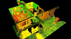
NOTTINGHAMSHIRE, U.K., (August 14, 2019) – A security technology firm reduced the time needed for public safety personnel to engage a simulated active shooter by providing the team with site floor plans created from 3D laser scan data. Prior to the exercise, the firm scanned the entire 112,000-square-foot building interior in just 2.5 hours with the GeoSLAM ZEB-HORIZON 3D mobile scanner.
“In the role-playing scenario staged at a mega-church, the off-duty police officers reached the shooter in up to 21 percent less time using a 2D floor plan generated from the laser scans,” said Robert W. Myers, CEO of Entropy Group LLC. “However, we expect engagement times to drop considerably by leveraging the 3D scan data to create virtual reality training simulations.”
Based in San Ramon, Calif., Entropy Group was established to save lives during active shooting incidents at schools and churches by providing law enforcement with the situational awareness information they need to reach perpetrators more quickly inside complex building spaces.
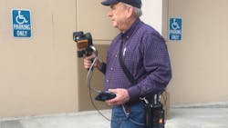
The firm uses the GeoSLAM ZEB-HORIZON handheld mapping device to capture 3D scans of school and church interiors, including small offices, classrooms and closets. The GeoSLAM software generates highly accurate 2D floor plans for use by responders, either hardcopy or digital, to navigate the interior of the building. The same data set can also be used to create virtual environments where multiple officers train on computers to respond to attack scenarios in realistic, immersive 3D simulations of actual schools and churches in their jurisdictions.
“Eventually, we plan to utilize machine learning technology that will allow individual officers of first responder teams to be dispatched to specific locations within the facility in real time to quickly reach shooter engagement locations within the buildings,” said Myers.
The handheld ZEB-HORIZON laser scanner allows users to map interior and exterior spaces in 3D at walking speed. The lightweight device captures up to 300,000 points per second with an accuracy of 1-3 centimeters up to 100 meters from the user. SLAM technology ensures points are tied to local coordinate systems even in interior spaces where GPS/GNSS coverage is poor. Large multi-room buildings that might take days to scan with a stationary scanner can be mapped in a few hours with the ZEB-HORIZON.
“Mobile laser scanning technology is the fastest and most cost-effective way to create the 2D and 3D building information tools public safety personnel need to prepare for a variety of emergency scenarios,” said Shelley Copsey, GeoSLAM CEO.
The GeoSLAM Hub software creates a fully integrated data collection and mapping workflow, enabling ZEB-HORIZON users to process, view, merge, edit and output 2D and 3D deliverables within minutes of data capture. Outputs include 2D floor plans, CAD, as well as an integrated workflow for the creation 3D building information models (BIMs).
Entropy Group is working directly with school districts and places of worship to provide scanning services and develop standardized procedures for the capture of 3D data inside their buildings. These reality capture data sets and derived 2D and 3D products will be provided to local public safety organizations for use in generating hardcopy and digital representations.
For more information on Entropy Group, visit https://entropygroup.net .
About GeoSLAM (www.geoslam.com)
Headquartered in the UK, GeoSLAM is a global market leader in “go-anywhere” 3D mobile mapping technology. Our unique handheld technology is highly versatile and adaptable to all environments - especially spaces that are indoor, underground or difficult to access, providing accurate 3D mapping without the need for GPS.
Our technology is easy to use and within minutes customers can build a highly accurate 3D model of their environment. GeoSLAM was founded in 2012 as a joint venture between CSIRO (Australia’s National Science Agency and the inventors of Wi-Fi) and 3D Laser Mapping. Serving the surveying, engineering, mining, forestry, facilities and asset management sectors, GeoSLAM has an expanding global network of over 70 distributors – including over 15 in US locations -https://geoslam.com/contact/.


